'There Will Be Mud' - Post-Wildfire Mud and Debris Flow Emergencies Challenge Firefighters
In October and November 2007, an unprecedented series of wildfires struck the entire southern half of California, and once again thousands of homes were either in flames or threatened by them, with firefighters experiencing burnovers that left some severely burned and many others with close calls.
And now it's time for the floods and mud and debris flows that inevitably follow the fires. The mountains of Southern California are among the most prolific producers of mud and debris flows anywhere. The reasons include the materials of which the mountains are made, the steepness of their slopes, the seismic processes that constantly push them skyward and the cycle of wildfires followed by heavy storms.
In December 1993, after the deadly "Old Topanga Fire" incinerated tens of thousands of acres and hundreds of homes in Malibu, Los Angeles County firefighters responded to a series of mud and debris flows, including one that trapped two people in a Jeep Cherokee at Big Rock and the Pacific Coast Highway. To the south, firefighters from the Orange County Fire Authority were confronted by a major mud and debris flow in Laguna Canyon.
Naturally, it's not always possible to position rescuers in every place that a mud and debris flow might occur. This is especially true in the more remote mountain areas. In February 1994 (following the "Kinneloa Fire," which denuded thousands of acres of steep mountainside above the cities of Altadena and Sierra Madre in Los Angeles County, a week before the "Old Topanga Fire"), a deadly mud and debris flow swept down Bailey Canyon. It was sunny in the canyon and the lowlands that morning, but a large thunder cell was dumping rain on the upper slopes of the San Gabriel Mountains. A 20-foot-high wall of mud, trees, boulders and other debris surprised many hikers, who barely escaped with their lives by climbing hillsides after they heard (and felt) the rumble of the approaching flow.
A father and his young son hiking in Bailey Canyon were unable to escape and tragically were swept away. Days later, Los Angeles County Public Works personnel experienced a close call when a secondary mud and debris flow struck while they searched for the father and son in the debris basin below the canyon. A TV news crew filmed the massive roiling wall of mud and debris scouring the canyon, carrying telephone poles and large trees. It was a graphic demonstration of the lethality of mud and debris flows.
After the 2003 Southern California fire storms, 15 people died on Christmas when huge mud and debris flows struck Waterman Canyon, a secluded and narrow crevice in the San Bernardino Mountains that was a focal point of the "Old Fire" (which, after it combined with the "Grand Prix Fire" in Los Angeles County, burned more than 150,000 acres and more than 1,000 homes and buildings, leaving a 32-mile swath of denuded slopes).
The family of the caretaker of a Greek Orthodox church camp was celebrating Christmas as a light rain fell through the morning, saturating the soil. By afternoon, the rain became an intense downpour. Suddenly a 14-foot-high wall of mud, boulders and 40-foot-tall trees crashed through the camp. Entire buildings full of people were ripped from the slopes and washed away. Some people climbed to higher ground, but others were washed away or stranded. One man, ripped from his children, was pinned by boulders and trees; hours later, firefighters freed him using chain saws and other tools. Suffering from hypothermia and other injuries, the man survived, but his children were never seen alive again. It took more than a week for firefighters and search and rescue teams to find all 13 victims.
On the same day, another large mud and debris flow struck a KOA campground near Devore, stranding 54 people and killing two victims. This area had also was below the "Old" and "Grand Prix" fires' burn areas, and the steep slopes were deep in ash and debris. At least one would-be rescuer (an insurance company claims adjuster who was in Southern California to help assess losses from the firestorms) died while attempting to help children he thought were in a trailer that slid down a hill.
Ironically, a multi-agency Burned Area Emergency Response (BAER) team, assembled to survey slope damage and potential for floods and other problems after the 2003 firestorms, had identified 30 main trouble spots where drainages were almost certain to produce significant mud and debris flows. The Devore campsite and Waterman Canyon had been noted as locations posing a high risk to life and property. At some of those sites, the BAER team had suggested ways to reduce flood danger, such as placing sandbags and digging ditches. But the danger at the Devore campsite was so severe that the team recommended evacuation during storms.
Clairemont Incident
At the same time San Bernardino County firefighters were fighting their way into the disasters in Waterman Canyon and Devore, the storm was hitting the San Gabriel Mountains in Los Angeles County and a similar mud and debris flow emergency was developing in the foothills of Clairemont, which marked the western end of the Grand Prix Fire burn area. Fortunately, this one was less deadly. As part of the Los Angeles County Fire Department (LACoFD) augmented Storm Deployment, a combination of swiftwater rescue teams and urban search and rescue (USAR) units strategically located across the county during major storms, USAR Task Force 103 (USAR-TF103) had already been dispatched on a Code R move-up to Fire Station 62 in Clairemont because the storm was causing mud and debris flows to occur in multiple locations, including mudflows that inundated the interior of that fire station.
In the midst of a number of simultaneous water rescue and mud-and-debris flow emergencies that began breaking out with the heavy downpours, LACoFD Engine 101 Captain Bill Masten radioed "Emergency Traffic" and reported people trapped by mud and debris flows in homes and at least one vehicle where Clairemont meets the steep mountain slopes. He requested USAR-TF103 to assist with the rescue of the motorist, which was conducted by personnel wearing swiftwater personal protective equipment (PPE), including dry suits. Then the two units worked with a unit from the U.S. Forest Service to rescue a pregnant woman and her young son from a vehicle trapped by another mud and debris flow.
At this point, USAR-TF103 was assigned to the "Baldy Branch" of the rapidly expanding incident where residents were being evacuated with assistance through mud and debris coming down from the mountains, with direction to establish a rescue plan, assign upstream lookouts to warn of additional mud and debris flows coming down-canyon, and to have a rapid intervention plan in place for all department personnel working in the danger zone. Citizens were safely evacuated from impacted neighborhoods, and LACoFD personnel, including the Heavy Equipment Section and several camp crews, attempted to divert the flows with sandbags and front-end loaders, and used jackhammers to breach retaining walls to let water and mud drain from homes and properties.
These are just samples of the havoc that mud and debris flows can wreak. And then there are the deadly mudslides that are closely related to mud and debris flows because they often happen under similar weather conditions and under similar circumstances of steep unstable slopes, saturated soil, and sometimes after large wildfires. The history of Southern California and other mountainous wildland zones is replete with major mud- and water-related events that help define the terrain and the places people choose to live.
One infamous town familiar to many readers is La Conchita along the 101 Freeway in Ventura County. In 1889 and 1909, parts of the 600-foot-high cliffs overlooking La Conchita collapsed, burying the Southern Pacific rail line that ran along the old Pacific Coast Highway. The later collapse buried an entire train.
These collapses were a precursor to a huge mudslide the occurred during the El Nino-spawned storm in January 1995. The cliff collapsed and buried a dozen homes, prompting the Ventura County Fire Department to establish a major multi-day search and rescue operation that included regional USAR units, swiftwater rescue teams, heavy equipment, camp crews, ground-penetrating radar specialists, geologists and soils engineers.
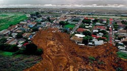
The 1995 mudslide, in turn preceded the disastrous mudslide of Jan. 10, 2005, when the same mountainside collapsed once again. This time, the event was filmed in its entirety by news cameras covering mud and debris flows that had trapped motorists on the 101 Freeway, with the Ventura County Fire Department already committed to major rescue operations there. Nearly three dozen homes were buried in a mudslide/debris flow that took only eight seconds to occur. Ten people were killed and dozens injured in that disaster, and the town remains under threat of future mudslides and mud and debris flows because the basic conditions that precipitated the 1889 and 1909 slides are still present.
What Are Mud and Debris Flows?
Author John McPhee, in his book The Control of Nature, describes a mud and debris flow that buried a neighborhood in LaCanada in 1978, following the huge "Mill Fire" that swept across the San Gabriel Mountains: "It was not a landslide, not a mudslide, not a rock avalanche; nor by any means was it the front of a conventional flood...In geology, it would be known as a debris flow. Debris flows amass in stream valleys and more or less resemble fresh concrete. They consist of water mixed with a good deal of solid material, most of which is above sand size. Some of it is Chevrolet size. Boulders bigger than cars ride long distances in debris flows. Boulders grouped like fish eggs pour downhill in debris flows...It was not only full of boulders; it was so full of automobiles it was like bread dough mixed with raisins."
The mud and debris buried several homes to the roofs. One family and most of their furniture was floated to the ceilings by the invading mud. They were trapped for several hours, faces to the ceiling with precious little breathing room, until Los Angeles County firefighters tore through the roof of the house to rescue them.
The mountains of the West are among the most prolific producers of mud and debris flows in North America. The tectonic forces that raise them are still at work. For example, the Northridge Earthquake raised sections of the Santa Susana and San Gabriel mountains 12 inches in seconds. The Northridge quake and its aftershocks sent millions of tons of rock and soil into canyon bottoms all across the San Gabriel Mountains and elsewhere. Every time the earth shook, clouds of dust rose out of the canyons as landslides rained down.
Not only did the Northridge quake increase the amount of debris; it greatly increased the probability of upstream natural dams that might form and burst, sending down huge walls of water, mud and debris. As Southern California dealt with the quake and braced for further winter storms, the possibility of disastrous mud and debris flows loomed large for firefighters in vulnerable areas.
And every day, regardless of earthquakes, rocks break and fall off the steep slopes continuously as the mountains erode. Moderate rain increases erosion and carries the broken rock into streams. Heavier rain begins moving even large boulders. As the hillsides become saturated, mud and rock slides begin filling the canyons with more debris. The heaviest debris normally remains in the canyons, creating rocky streams and occasional natural dams. The debris may pile up in this manner for years.
Intense rainfall can mobilize the accumulated debris with disastrous results. A good example is found in Southern California, where the winters are often characterized by severe storms sweeping in from the Pacific Ocean and stalling when they hit the mountains, dropping millions of tons of water into steep, narrow canyons. Despite the usually arid climate, the San Gabriel Mountains have seen some of the most intense rainfall recorded anywhere on Earth. In 1978 (the year of the "Mill Fire"-related debris flows), 12 inches fell in 24 hours and 1½ inches poured down in one five-minute period, causing a debris flow 25 feet high that swept at least 13 people to their deaths in an area off Angeles Forest Highway. In 1933, over 30 people were killed by a large debris flow from the San Gabriels near Glendale/Montrose. Twenty-six inches fell in 24 hours in 1943.
Conditions that mobilize debris flows often cause multiple simultaneous events in different canyons, confounding rescuers trying to reach trapped victims. If one canyon is flooding, chances are good that adjacent canyons are being hit hard at the same time. Major debris flow events have occurred in California during at least 24 rainy seasons since 1905. It is estimated that one ancient flow sequence in the Wrightwood area (long before it was populated by Europeans) dislodged 18 million yards of material and transported it 15 miles into the desert, burying the future town site under dozens of feet of material.
Mud and debris flows in steep terrain commonly move faster than 20 mph, and they have been known to travel faster than 100 mph. Debris flows have moved rocks measuring 20 by 30 by 40 feet. One debris flow in the Tujunga area of Los Angeles County transported a boulder weighing 15 tons into a residential area two miles from the San Gabriel Mountains.
Wildfire Effects
The extreme heat of wildfires can coalesce plant life and soil into a coating that repels water. Chaparral contains high levels of long-chain hydrocarbons (oils) that help maintain internal moisture in the arid climate. Chaparral litter gives up these complexes to the soil as it piles thick in the years between wildfires. When intense fires occur, the waxy compounds are vaporized, condensing in a layer a few inches below the ground. The layer of soil just below the surface essentially becomes hard and waterproof.
Dry, unconsolidated particles of soil, rock, ashes and other material is left in thick layers on steep canyon walls. Without plants and roots to hold it to the slopes, the particles cascade down hillsides in a steady dry stream of chunks. High winds under these conditions have been known to create dust storms. In essence, the canyons are being "pre-loaded" for debris flows.
Here's how it happens: Rain is the trigger; in even moderate rainfall, topsoil can quickly become saturated, increasing the pore pressure just above the hydrophobic (waterproof) layer. The soil then liquefies and begins moving downhill, seeking the path of least resistance (as in a stream), forming small canals called "rills" across the hydrophobic layer. The rills speed the water downslope, sometimes increasing the velocity threefold (and increasing the transport capacity a thousandfold). As rills develop across the face of the burned slopes, they connect, forming small tributaries leading to the bottom drainages. Massive loads of debris can be mobilized by relatively small amounts of rainfall. With the onset of intense rainfall, the trigger is set, the trap is sprung, and anyone down canyon is vulnerable to the unannounced arrival of huge walls of mud, rock, water, trees, and sometimes homes and cars.
For reasons still not entirely understood, wildfire burn areas seem to attract tremendously intense rain. The burned areas appear to act as separate microclimates, attracting storm cells that concentrate directly over the denuded terrain. This creates one type of worst-case scenario (denuded soil) overlaid by another worst-case scenario (intense rain in steep topography). As noted by McPhee, an inch of rain on an area of mountain 10 by 10 miles is approximately 7.2 million tons of water. Mix that amount of water with millions of tons of rock, soil and other debris, add the runoff factor caused by the hydrophobic layer and the stage is set for disaster.
Rescue Training
Heeding the warnings of geologists, soils engineers and the LACoFD's Forestry Division after the 1993 firestorms, Fire Chief P. Michael Freeman and his staff assigned Battalion Chief Terry DeJournet and Firefighter Vern Atwater to develop training to prepare firefighters and other rescuers to evaluate mud- and debris-flow situations, recognize danger signs, request proper rescue resources, and manage rescues with maximum safety and efficiency. Atwater and DeJournet made a "blitz" attack on the project, conducting extensive research with geologists, soil engineers, public works officials, rescue experts, the California Division of Mines and Geology, the U.S. Army Corps of Engineers, the Federal Emergency Management Agency (FEMA), the California Office of Emergency Services and others. Key elements of the program, presented to personnel in the high-hazard burn areas, were as follows:
- Recognition of conditions contributing to mud- and debris-flow potential.
- Understanding that the first "wave" of mud and debris may not signal the end of the event, but merely the beginning. Frequently, multiple "waves" of mud and debris will follow the first. The ensuing waves may be larger than the initial flow.
- Do not commit personnel to hazard areas without establishing an upstream spotter (to warn of additional "waves"); a warning system; proper safety equipment; and an escape plan.
- Mud/debris flows (like water) generally follow the path of least resistance. They tend to follow stream beds. However, the large amount of solid material within them may block channels, diverting flows elsewhere, and completely changing the hydrology in a matter of seconds.
- A solid object is only 22% of its normal weight when it is being moved by a flow. Rocks and huge boulders may roll or even float in the flow.
- In some areas below major burns, entire neighborhoods may be buried.
- Severe flash flooding independent of debris flows is possible in adjacent areas that have not been burned. This may cause other problems for rescuers.
- Flooding and mudslides may completely block access to many areas. Bulldozers, helicopters, four-wheel-drive vehicles and other special transportation will be needed. In some cases, all these modes may be ineffective, and hiking in by foot may be required.
- Some events may create life-threatening conditions to rescuers. In these cases, all search and rescue efforts may be delayed until water and mud stops flowing, until hillsides can be secured, until daylight breaks or until weather conditions abate.
- In some cases, the most prudent action is total evacuation of entire canyons and other endangered areas as a precaution for the approach of major storms.
- Special equipment, tools and supplies will be required to conduct rescue operations when mud and debris flows occur. Required items may include plywood, screw jacks, pipe, four-by-four-inch and six-by-six-inch wood struts, airbags, umbilical air self-contained breathing apparatus (SCBA) systems, shovels, buckets, hammers, nails, "avalanche poles" and swiftwater rescue gear.
- Search-dog teams may save victims if promptly dispatched.
- There are effective methods to rescue victims buried in void spaces created by mudslides. All personnel should become familiar with the basic "game plan" for these rescues.
- Fire crews and other sources of manpower will be especially important to rescue efforts.
- Nighttime operations may be especially dangerous. Anyone who has operated at a nighttime rescue in the rain knows that visibility and communications may be extremely poor. Personnel efficiency is down due to wet, cold, muddy conditions. Upstream safety personnel may not see a wall of mud and debris until it is too late. Personnel committed to a rescue operation in the danger zone will be even less likely to escape in time if something goes wrong. The most extreme caution should be used for operations at night.
- Unified command is likely to be required because multiple agencies may be involved.
- A systematic approach should be used when homes and vehicles are buried. Thorough search, documentation of results and marking of sites should be accomplished. Use the international USAR collapse-site marking system adopted by the California Office of Emergency Services and FEMA USAR task forces.
- Victims may be alive inside structures buried in mud and debris, even if a structure is completely covered. Access via the roof may be necessary. This may require traditional truck company ventilation/access techniques (cutting through the roof with axes and chainsaws). Victims may be trapped in void spaces.
- Live victims may have "floated" to ceilings as mud entered a structure. Therefore, use only shallow chainsaw swipes when cutting through the structure into the living spaces to prevent injuring victims. Use search cameras to look before cutting when possible.
- Trench-collapse rescue materials and techniques may be required to make access and conduct rescue.
- Access may be made via helicopter, aerial ladder or multiple ladders laid over the mud to spread the weight of rescuers and prevent sinking, or plywood for the same purposes. Heavy bulldozers, front-end loaders and similar vehicles have been successful.
In December 1993, just as the new Mud and Debris Flow Safety and Awareness Course was being presented in areas affected by the firestorms, a huge Pacific storm approached Southern California from Alaska. The LACoFD deployed 10 swiftwater rescue teams, augmented by a reserve USAR unit (USAR-2). On the first morning of the storm, USAR-2, staffed by LACoFD Captains Scott Smith and Troy Flath, helped Truck 125's members teach the course to other stations in the Malibu area. Two hours later, severe thunderstorms occurred over the "Old Topanga Fire" burn area. Almost immediately, Malibu experienced serious trouble as several life-threatening situations occurred simultaneously.
The worst incident was a huge mud and debris flow that roared over the banks of Big Rock Creek, where many homes had burned. The creek is normally a trickling stream that crosses under the Pacific Coast Highway and drains into the Pacific Ocean. Now it had become a river of mud and boulders that washed down the canyon only minutes after the downpour struck. The mud and debris poured off the hillsides like brown lava, clogging the creek in several places. As the debris "dams" burst, they sent waves of debris down the canyon, turning the entire canyon into a torrent of mud and rock. The flood immediately clogged the channel under the Pacific Coast Highway and swept across the road, trapping people in cars and homes, which blocked the mud from going into the ocean, creating a damming effect that quickly raised the flood to the roof lines of some homes.
Battalion 5, Engine 70, Swiftwater 70, USAR-2, an LACoFD swiftwater/helo team-equipped copter and other units found dozens of people trapped in various predicaments. Extra resources (including front-end loaders from Los Angeles County Public Works) for access and rescue in the flowing mud) were requested, and full-scale rescue operations began. The most life-threatening situation appeared to be a couple whose Jeep Cherokee had been swept into the middle of the debris flow. Mud was up to the windows and rushing by at great speed. The Jeep was foundering adjacent to the point where the creek normally drops under the highway. If pushed into the dropout point, the vehicle and its occupants would be buried in 15 feet of slurry.
After sizing-up the situation and assigning a firefighter as upstream lookout, Smith coordinated as Flath and Firefighter Steve Linnel (Engine 70) donned swiftwater PPE and attempted to rescue the couple. A front-end loader was at the scene, and the Public Works driver volunteered to drive it into the flow with the two firefighters in the bucket. Flath and Linnel climbed into the bucket and the tractor drove into the flow. Mud and water were still rushing out of the canyon, and additional walls of debris were a constant threat, but they removed the couple to safety. Several front-end loaders were used to rescue other civilians from rooftops and second-story balconies. Smith conferred with the incident commander, who ordered the entire hazard area to be evacuated in case of additional, larger flows.
Conclusion
The Big Rock rescues offer a possible preview to some of the conditions that firefighters and other rescuers may encounter in areas burned by the 2007 firestorms. Conditions are ripe for mud and debris flows to occur in these areas during the next several winters. The BAER reports for Southern California's huge burn areas are clear in their warnings, which frequently include language like this: "The pre-fire condition of the watersheds already included possible risk from landslides, debris flows and rock falls. These hazards are part of the natural processes in this environment, and were present under pre-fire conditions.
"The risk from landslides, debris flows and rock falls are possible where roads, residences or other development are located on alluvial fans, colluvial footslopes and debris fans and the risk from debris torrents and flooding from increased surface water runoff are possible where residences or other development are near stream channels or on low stream terraces...occupied areas within or adjacent to the fire perimeter can expect higher than normal flows with possible bulking/debris flow and landslides in all rain events. The higher the rainfall intensity the higher the risk for landslides, flooding and debris flow throughout all burned area basins. This threat includes the loss of life and property."
BAER reports for the "Canyon Fire" and "Corral Fire" burn areas warn: "The principal concern with the 'Corral Fire is loss of human life and property due to an increase in the potential for in-channel floods, hyper-concentrated floods, debris torrents and debris flows. Houses and communities near or within stream channels...appear to be in positions where significant in-channel floods, hyper-concentrated floods, debris torrents, mass wasting and debris flows are possible. In addition, possible loss of life resulting from localized debris sliding, debris flows, and sediment laden floods onto individual homes beyond the areas described previously is also possible.
"Fire and flood are historical components of the 'Corral' and 'Canyon Fire' area as evidenced by four fires in the past 10 years, in some cases followed by flooding. As such, local governments and private landowners have been active for many years in cooperative post-fire assessments, mitigation or treatments, predictive modeling of mudflows, etc."
LARRY COLLINS, a Firehouse® contributing editor, is a 27-year member of the of Los Angeles County, CA, Fire Department, where he is a captain, USAR Specialist and paramedic assigned to USAR Task Force 103, which responds to technical rescues and multi-alarm fires across Los Angeles County. He is a Search Team Manager for the department's FEMA/OFDA USAR Task Force for domestic and international response, and he served as an USAR Specialist on the "Red" FEMA USAR Incident Support Team since 1990. He authored the textbook series Technical Rescue Operations, the "Rescue" chapter of The Fire Chiefs Handbook, and the "Rescue" chapter of the upcoming Handbook for Firefighter I and II.
REFERENCES
DeJournet, Terry and Atwater, Vern. "Los Angeles County Fire Department Urban Search and Rescue Mud and Debris Flow Safety Awareness Course," 1993.
Wells III, W. "The Effects of Fire on the Generation of Debris Flows in Southern California." Geological Society of America Reviews in Engineering Geology, Volume VII 1987.
DMG Note 33 "Hazards from Mudslides...Debris Avalanches and Debris Flows in Hillside and Wildfire Areas". California Department of Conservation Division of Mines and Geology.
Campbell, R. "Soil Slips, Debris Flows, and Rainstorms in the Santa Monica Mountains and Vicinity, Southern California."
McPhee, John "The Control of Nature": "Los Angeles Against the Mountains."
