Knowing Your First-Due: Top Views For Size-up
How well do you know your first-due area? I would like to take a look at some ways to easily help you learn more about your primary response area and how to enhance your operations at the same time.
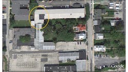
This month, we are going to look at your first-due from the topside. Mapping programs such as Google Earth, MapQuest and a host of others, coupled with the availability of tablets, smart phones and laptops, allow us to look at our first-due from a whole new angle and vantage point.
Prior to the arrival of these programs and apps, we had to rely on aerial photos and GIS system printouts. Carrying these printouts posed a problem themselves due to bulk and size. I can remember having a piece of PVC pipe bungee-corded to the trunk lid to hold aerials, overhead views and other maps due to their size. Over the years, I have found it handy to have aerials or a GIS printout for the box areas or a specific section of the first-due such as a downtown section.
These prints, or the online maps, can give you a boatload of information and give you an advantage when trying to size-up. Things look different from the topside. A view from the top can let you see how buildings are attached and interconnected and how the exposures can be impacted.
In a rural setting, you can get a good bird’s-eye view of the layout of the area and know where ponds are located for water supply, find access lanes and know what exposures there are.
Dedicated dispatch and alerting programs, and the many navigation apps can provide this information along with routing while en route to calls. On a recent response on a mutual aid ladder truck run, our captain brought the location up on his phone, and was able to see the different roof types, site access and exposure issues and view a layout of the building all prior to arrival. The size-up really started as soon as our truck hit the street.
Attaching copies of the aerials to your box cards or street maps is one way to capture this. Redoing your maps using Visio and Google Earth to show a satellite view and having all the information in one place is great. You can then have this data for each of your box areas, or just bring it up on your phone or tablet while en route. Whether hard copy or electronic is another discussion, but no matter how you access the information it is a great tool.
Start by visiting one of the mapping sites and look at your response areas and you will be surprised as to what you see. What a building looks like at street level and what it looks like from topside may be totally different.
Also, take the time to find some high ground in your community, whether it be a tall building or a natural overlook to take a look at things from above to have a better grasp and understanding of your first-due and its hazards, needs and uniqueness.
This information can be tied to pre-plans or even linked to response and alerting programs to display at the station when responders are turning out or on your personnel computing devices with programs.
