Technology Supplement: CAD and the Fire Service
Computer-aided dispatch (CAD), also known as computer-assisted dispatch, is a method of effectively dispatching and tracking emergency service incidents through the assistance of a computer with CAD program software. CAD originated in the area of law enforcement. For many years, the CAD functionality for the fire service had been limited because the law enforcement dispatching procedures were much different than that of the fire service. Over recent years, the CAD vendors have been actively engaged with public safety organizations like the International Association of Fire Chiefs (IAFC) and the Association of Public Safety Communications Officers International (APCO) to learn more about fire service needs. Presently, CAD systems offer more functionality and value to the fire and EMS service than ever before.
Generally, a call is received through an Enhanced 911 (E911) telephone system, which automatically displays address location and phone number (ALI/ANI) information. This ANI/ALI call information is integrated/interfaced from the E911 and populates this information into the CAD system. A call taker or dispatcher then adds the incident information into CAD. Based on the incident location, location of assets and call type, the CAD system generates a dispatch recommendation. These station/unit recommendations are based on response criteria developed by each locality’s emergency service protocols. Once the dispatcher accepts the response recommendation (or makes a change/correction), the CAD will generate selective station/unit tones through an encoder connected to the land mobile radio system. Depending on the CAD, the voice dispatch may be performed by the dispatcher or on newer CAD systems it may be entirely automated through a digital voice rendering over the radio system.
CAD has dramatically changed the way that 911 calls are received and dispatched. The information/data is immediately captured and documented within a system database, which includes the phone number, address, call type, call related times (call received, dispatch time, unit responses, unit arrivals, units in service). Once the information is populated into CAD, CAD may provide station/unit recommendations, recommended response routing, access to online pre-fire plans, automatic vehicle location (AVL) of emergency units, access to hazardous material information and more. Much of this information is automatically populated into or accessed from a fire department records management system (RMS). CAD also provides the quick and easy means of updating unit status and a way to activate other dispatch functions with just a few keystrokes or clicks of a computer mouse. CAD systems that integrate emergency unit AVL are able to make response recommendations based on the closest available unit to ensure the best possible response time.
Some of the most important features within CAD are: Quick and easy incident data entry, which includes minimized keystrokes, drag-and-drop dispatching functionality, CAD-to-CAD interface with other jurisdictions, automatic radio log entries, instant search/playback capability, incident status timers/alerts (unit response delay, accountability time intervals, firefighter Mayday situations, incidents that have not been dispatched, premise information, duplicate call notification, etc.).
Other important features include:
Silent or Messaging Dispatch
In addition to voice dispatching, most CAD systems today provide automated text messaging to individuals or groups directly to pagers, smartphones, tablets and email. The information for this text alerting is preloaded into CAD and occurs simultaneously to the identified users and their assigned devices. Often, the text message alert is received more quickly as it is transmitted as data and it does not have the delay of the transmission of selective tones that precede the voice dispatch.
Mobile/Apps
Yes, there’s an app for that. In our world of smartphones, tablets and computers, there are applications (apps) now available that can interface with the CAD system and provide all of this information instantaneously to a variety of mobile devices. Some of these mobile apps also allow direct unit status updates to CAD (in service, responding, on scene, returning to quarters and in quarters). On the mobile devices that have GPS capabilities, the apps can also provide an AVL interface with CAD that automatically updates CAD recommendations of closest unit dispatch. The apps also add the functionality of response route recommendations, access to pre-fire plans, access to hazardous materials data, etc. These features dramatically reduce emergency radio traffic and lessen the workload on the dispatchers. Time saving and effectiveness building features become more important during a significant emergency incident or a large-scale event.
Mapping/Geographic Information System (GIS) Interface
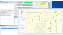
CAD systems today also offer either its own mapping solution and/or interfaces with a locality’s GIS data layers. This geospatial information is invaluable as it gives a quick look at the number and location of incidents that are currently active and can provide additional information such as online real estate files, etc. This identifies trends such as incident location clusters that may result from a significant incident, a severe weather event, etc. GIS information can also bring in other information such as traffic conditions, damage assessments, power outages, earthquake activity, flooded areas, snowfall amounts and more. AVL information provides a geospatial reference (on a map) to the location of assets and can quickly provide a view of unit utilization and availability. This is crucial to knowing when asset utilization is reaching critical mass to help initiate the request for additional resources from neighboring jurisdictions. AVL is a geospatial function that helps to identify and dispatch the closest unit to the emergency incident.
Interface with other records management systems
CAD systems now have the ability to communicate in a two-way fashion with fire records management systems (fire RMS). This achieves several things. First, CAD can automatically initiate an incident report and populate data on the call type, unit(s) assigned, incident times (call taken, call dispatched, unit responses, unit arrivals and units ready for service) and address. Modules that provide pre-fire plans can access information about the specific occupancy, Knox Box locations, hazardous material locations, location of handicapped occupants and other challenges in the building. This information can also alert incident commanders as to previous responses to this address.
Developing a CAD-to-CAD standard
In public safety systems, standards and standardized data practices are under discussion to allow disparate CAD systems to exchange incident information (CAD-to-CAD interface).
APCO is working on a project called the Unified Computer-Aided Dispatch Functional Requirements (UCADFR) toward the purpose of CAD-to-CAD standards development. The following information is provided from APCO’s website (https://www.apcointl.org/resources/unified-cad-project-ucads.html):
“Public safety stakeholder disciplines include emergency communications, law enforcement, fire service, EMS and the CAD provider industry. The UCADFR will be an invaluable resource to these communities by supporting the planning, acquisition and management of full-featured CAD software applications. Practitioners writing RFPs for CAD systems to support multi-service dispatch centers will benefit from the revised CAD functional specifications document.”
North America National Information Sharing Initiatives (US & Canada)
In the United States, Mutual Aid Net involves 20 states using a software application that is designed to serve as a resource database and mutual aid deployment tool. The development of Mutual Aid Net was funded by FEMA, and accomplished under contract with the International Association of Fire Chiefs, which operates the system utilizing several hardened data server sites around the country to provide a highly reliable resource to fire and related emergency services.
In Canada, a similar interoperability project is underway involving the Canadian Safety and Security Program (CSSP). Over the past three years, this project involves a solution called the Multi-Agency Situational Awareness System (MASAS). MASAS connects different departments’ systems in a way that allows the exchange of real-time, location-based incident information to public safety responders and emergency managers. More information on this can be found at the following website: http://www.firefightingincanada.com/equipment/interoperable-response-19130#sthash.6gPiIV9j.dpuf
Additionally, the National Information Sharing Consortium is working in collaboration with a joint White House/Department of Homeland Security (DHS) initiative called the Incident Management Information Sharing Consortium Sub Committee. The purpose of this initiative is to engage public safety responders for their input for the purpose of developing a standardized national approach to information sharing environment. This effort is mainly focused on the standardization of data format and folder design.
A General List of Fire Service Questions When Purchasing a CAD System
- Can fire personnel view and update multiple pieces of critical information from the central map screen, such as unit status, hazardous chemicals onsite, call comments, zones, current weather conditions, cross streets, alternative entrances, Knox Box location, gas shutoff valves, emergency exits, etc.?
- Does the software determine and display the quickest route to a call based on actual drive time, taking into account local street networks and barriers such as rivers, canyons and limited-access highways?
- How efficiently does the CAD product handle multi-agency and multi-jurisdictional dispatching?
- Can agency information be shared (law to fire, fire to law, etc.) easily as approved by the jurisdiction?
- Can firefighters get direct access to dispatch information without utilizing radios?
- Does the view update in real time as dispatchers add new call comments?
- Does the software allow the incident commander and fire personnel to quickly see the real-time location and status of all calls and units via color coding or some other method? Are those codes customizable to meet your own department’s needs?
- Can personnel be alerted when pre-determined time limits have lapsed?
- Does the software give fire personnel access to critical premise information, such as contact information, floor plans, alarm locations and hazardous materials – including integration to the full National Oceanic and Atmospheric Administration (NOAA) CAMEO Chemicals system?
- Can the CAD system interface with voice/alphanumeric pagers, smartphones, faxes, printers, tablets, computers, printers and landline phones?
- What mobile (smartphone/tablet) platforms will this program work on (Android, Apple iOS, Blackberry, Windows)?
- Can the CAD system integrate/utilize Pictometry data?
- Does the CAD software provide a “dashboard” feature that provides quick snapshots of incident activity?
- Can the software capture, receive and/or send digital images video to field units via smartphone, tablet and/or computer?
Wrap Up
Computer-aided dispatch is the critical first step to initiate a dispatch/response of emergency resources to an emergency incident and the first phase of information sharing. A properly designed CAD system will greatly enhance the effective utilization of emergency resources throughout the emergency incident cycle. While a general list of questions for fire service consideration when purchasing a CAD system has been provided, it is highly recommended that this process be inclusive of all the parties (agencies) involved and that a consultant with CAD expertise be utilized to facilitate the development of a comprehensive request for proposals (RFP) due to the nature and complexity of this procurement.


