Geographic Information Systems (GIS) has become an essential element for effective public safety programs. Esri, the largest GIS company in the world, defines this concept as the “Science of Where.” For public safety, the Science of Where is not enough to truly understand complex incidents or disasters. To achieve an acceptable level of situational awareness requires not only the where but also the who, what, when and how. Specifically, public safety needs to know where the emergency is, who is impacted, what is involved and how it is affecting the community. GIS enhanced with other data helps communities answer these questions. One national organization depends on and advocates for GIS to help public safety to understand situational awareness and share it with multiple responders, jurisdictions and citizens simultaneously—the National Alliance for Public Safety GIS (NAPSG) Foundation.
Disaster response
Just hours after Hurricane Harvey made landfall on Texas, phone calls and emails came pouring into the NAPSG Foundation office with questions about everything from how to get access to infrastructure data, how to implement the U.S. National Grid, and how to optimize crowdsourcing efforts and tools for search and rescue (SAR) operations. Leadership and staff at NAPSG Foundation quickly responded to the calls for service, in collaboration with several partner organizations and agencies. Concurrently, as Harvey was making landfall, NAPSG Foundation supported the public safety community by working in cooperation with the Department of Homeland Security (DHS) and the Federal Emergency Management Agency (FEMA) to stand up a geospatial open data site known as HIFLD for Harvey (https://respond-harvey-geoplatform.opendata.arcgis.com). HIFLD (Homeland Infrastructure Foundation-Level Data) for Harvey brought together the best available data related to Harvey response in a single place, thereby easing search and access to relevant incident data that would be useful for and used by first responders.
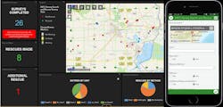
During Harvey, the NAPSG Foundation received calls for assistance from local first responders working on the ground in SAR missions and damage assessment. The NAPSG Foundation, in partnership with the International Association of Fire Chiefs (IAFC) and Esri, was called-upon to help Florida-based local SAR teams achieve situational awareness on field operations as they provided mutual aid to Texas during Harvey. The NAPSG Foundation and the IAFC moved quickly to address this need. In less than 24 hours, they developed and provided on-the-ground teams with an initial tool set (https://www.iafc.org/blogs/blog/iafc/2017/09/15/iafc-partners-deploy-apps-to-help-texas-florida-hurricane-responders) for gathering field information, as well as an operations management dashboard for SAR leaders that automated the integration of field information.
With Hurricane Harvey response still underway, requests for support also began coming in from first responders gearing up for Hurricane Irma landfall. Local and state SAR teams in Florida had heard about the toolset that the NAPSG Foundation and the IAFC provided to a few SAR team during Harvey. When they formally requested similar tools as they prepared for Irma landfall, NAPSG and the IAFC moved swiftly in developing and deploying an enhanced suite of decision support tools and field data collection applications.
An estimated 300 local and state fire and SAR responders representing roughly 56 teams or task forces utilized the tools as they prepared for and responded to Hurricane Irma. The tools and capabilities were made available to first responders that did not otherwise have access to field-level situational awareness tools, dashboards for resource management, and/or field information collection tools that fulfilled the information requirements of field operators and decision-makers.
While the NAPSG Foundation and IAFC suite of decision support tools were used by local SAR teams during Irma response, luckily the path of the storm changed and thereby lessened the impact on Florida and reduced the level of SAR operations required.
NAPSG Foundation’s Chairman, Rand Napoli, commented on the importance of GIS in disasters: “Demand has never been higher for GIS-based field information and situational awareness tools as we’ve seen in the 2017 Hurricane Season. Public safety leaders and first responders know now, more than ever before, that GIS-based tools save time in decision-making and increase response speed. In a disaster, speed is life.”
The NAPSG Foundation went on to conduct a Hurricane Irma Search & Rescue Hot Wash and Workshop co-hosted with the IAFC, the Florida Fire Chiefs Association and the Florida State Fire Marshal. The Hot Wash allowed local first responders to discuss lessons observed, challenges and technology solutions that would better prepare them for the next event. Among the key lessons learned identified during the Hot Wash was an urgent need for a standardized suite of GIS-based tools for fire service and SAR teams that can be developed, implemented and trained/exercised for both routine events and large-scale disaster. This standardized toolset must be designed and made accessible not only by FEMA-supported National Urban Search and Rescue (USAR) Task Forces, but also by local and state SAR teams and other local first responders. Routine use of a consistent and standardized sets of tools would facilitate broader adoption, familiarity of the tools by first responders, and maintain currency of the skills needed to use them in both day-to-day and large-scale events.
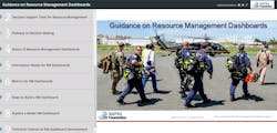
Additionally, the NAPSG Foundation moved quickly to pull lessons learned from the GIS-based tools used during hurricanes Harvey and Irma to inform national guidance. In December 2017, with support from the DHS Science and Technology Directorate, the NAPSG Foundation publicly released National Guidance on Resource Management Dashboards (https://www.napsgfoundation.org/all-resources/standard-operating-guide-templates), which provides a consistent framework and functional specifications for developing and using GIS-based dashboard technology to support resource management. The guidance is designed to support all public safety and all incident types and scales.
The NAPSG Foundation’s support to the community in times of disaster doesn’t stop there. During all three major hurricanes in 2017, the NAPSG Foundation stood up crowdsourced photo maps that were used in local and state emergency operations centers (EOCs) to support field-level situational awareness. The Hurricane Irma Crowdsourced Photo Map (https://www.arcgis.com/apps/StoryMapCrowdsource/index.html?appid=65f0dde429504c3cb07f0cae0f2c4be6) aggregated nearly 650 photos from the field, providing visibility on damage to structures, debris, water level, storm surge, and other key indicators on impact. Photos were gathered through crowdsourcing social media and other media sources in partnership with GIS Corps. Both the Florida and Georgia EOCs used the photo map to provide initial situational awareness at the field level over the entire impacted area, prior to the availability of images from official sources, satellite imagery, and aerial imagery.
Additionally, over the past two years, the NAPSG Foundation has been working to formalize its emergency response team, known as TRIAGE, so that the organization is fully ready and equipped to provide the types of assistance that are requested in preparation for and response to the next major event before it strikes.
NAPSG Foundation Executive Director Peter O’Rourke stated: “Our experience in supporting the 2017 hurricanes provide a clear case for just how crucial it is to support first responder agencies in clear skies—the preparedness phase. During this time, they can gain access to, train on and exercise with GIS-based tools that support enhanced operational coordination and situational awareness.” He added: “This is precisely why we are standing-up TRIAGE and what it is designed to support. First responder agencies need support in standing up tools using their existing GIS software. With TRIAGE, we will be able to scale our operations to better prepare and answer calls for assistance when the next disaster strikes.” The NAPSG Foundation is developing TRIAGE in collaboration with Esri to augment the support it provides through the Esri Disaster Response Program, and is open to partnering with other private sector entities in launching and operating TRIAGE.
As TRIAGE development continues, the NAPSG Foundation currently provides first responders with a variety of publicly available tools and no-cost training opportunities designed to increase the geospatial preparedness of local emergency response agencies. Rebecca Harned, NAPSG Foundation’s director of national and federal programs, highlighted some of the key tools available for this purpose: “Our Web-based Capabilities & Readiness Self-Assessment Tool (CARAT; napsgfoundation.org/carat) is publicly available for use by public safety agencies today. It allows local officials to measure and track their progress in integrating GIS capabilities throughout their planning, preparedness, response and recovery efforts. It also provides agencies with guidance that they can use to inform investments in staffing, technology and data to increase geospatial maturity.”
In sum
GIS is now a necessary tool for all fire service organizations to analyze their response times, determine fire station locations, real-time location data/situational awareness, and more. For fire departments that aspire to be accredited, GIS analytics and reporting is necessary to validate a departments overall effectiveness. If your department wishes to know about or expand their knowledge on GIS, the NAPSG is a great place to start!
Sidebar: Training Opportunities
The NAPSG Foundation conducts a series of no-cost virtual training (napsgfoundation.org/events) sessions each year and hosts the annual National Geospatial Preparedness Summit (NGPS), a training and exercise event for public safety leaders and GIS staff. Participation in NGPS is free for the public sector and registration is slated to open in May 2018. A limited number of private sector sponsorships for NGPS are available annually. For more information, contact Peter O’Rourke at (202) 895-1711 or [email protected].
Charles Werner
CHARLES WERNER, who is a Firehouse contributing editor, is a 45-year veteran of public safety. He served with the Charlottesville, VA, Fire Department for 37 years, serving the past 10 years as chief. Following retirement, Werner served for two years as senior adviser and acting deputy state coordinator for the Virginia Department of Emergency Management. He has chaired: DHS SAFECOM Executive Committee; IAFC Technology Council; National Information Sharing Consortium; and DHS/White House Incident Management Information Sharing SubCommittee. Werner currently serves as the director of DroneResponders Public Safety Alliance, chair of the National Council on Public Safety UAS and chair of the Virginia Secure Commonwealth UAS Sub Panel.
