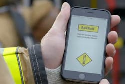
In August 2015, I wrote a column that highlighted the CSX Operation Respond app that provided real-time rail information from CSX Railroad. Today, the CSX Operation Respond app no longer exists; its functionality was merged into the AskRail app. The great news is that the AskRail app’s developers (Railinc and the Association of American Railroads [AAR]) are collaborating with public safety organizations to continually enhance the app for first responders.
The AskRail app, which was released in 2014, provides real-time rail car information and full consist (all rail cars) from all Class I railroads in North America. Additionally, it provides real-time rail car information from the Short Line (smaller railroads), including Amtrak. Presently, AskRail has more than 25,000 first-responder subscribers in all 50 states and eight Canadian provinces. It comes in English and French versions. It’s available for Android and iOS devices as well as computer desktop systems.
What’s so exciting about AskRail is that it has a user-friendly interface that walks the first responder quickly through a simple process to access key information. In a series of clicks, a responder will have the critical information that’s needed to assist in an effective mitigation. Everything within the use of the AskRail app is based on standard hazardous material response/mitigation procedures.Five clicks
When you open the AskRail app, you have the ability to enter the identifying number of a rail car. The result: The contents of that rail car will be displayed by name and by UN placard. (UN numbers are assigned by the United Nations Committee of Experts on the Transport of Dangerous Goods.) If the rail car contains a hazardous material, it’s identified on the app as such with appropriate markings.
If a hazardous material is involved, a second click permits the first responder to link to the associated reference page in the Department of Transportation Emergency Response Guidebook (ERG). The guidebook provides information on mitigation procedures, health hazards, first aid and evacuation/isolation distances.
A third click provides the full consist (all cars) of the train, their contents and their position amid the length of the train. Of course, this is important, because if you find a rail car that presents a hazard, you need to know what’s next to it. If a rail car is on fire, you need to know whether there’s hazardous material immediately adjacent to it.
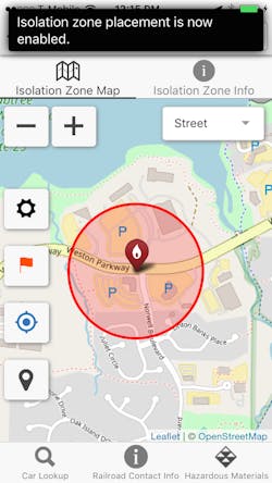
The fourth click of the AskRail app takes you to a page on which you’ll find the distances that are associated with the problem at hand that you need to consider regarding a possible evacuation of the surrounding area.
Finally, a fifth click provides a spreadsheet of all of the rail cars in the train. This can be used by the incident commanders (IC) or their operations team. If they want to divide the train into sections, ICs or their team can hand off sections of the spreadsheet to direct members to the cars that are their responsibility.
Catalyst of changeThe AskRail app is more useful than FirstNet/AT&T, because it ensures access with first-responder priority and preemption when access is needed the most. Of course, there are very rural areas of the country that lack broadband connectivity. That said, in an event in an area such as this, a dispatcher could access the desktop version of AskRail via computer and relay information to responders in the field.
The first iteration of the AskRail app required two separate apps to provide rail car information and isolation zones (the latest version doesn’t), but the development was important nevertheless, because the goal was to accommodate all of the Class I railroads. Unsurprisingly, CSX’s Operation Respond app dealt only with the railroad company’s lines, and that only applied to 22 states. The Operation Respond app did excel in regard to its GIS (geographic information system) component, which permitted the identification of structures in an area for which an isolation zone would need to be created.
The AskRail app didn’t include GIS functionality initially. It does now, and that is the result of CSX’s decision to forgo its app in favor of allowing Railinc and AAR to carry the freight on a real-time rail-car-information app. The Public Safety Rail Advisory Committee helped to usher the transfer of Operation Respond technology to the AskRail app development team.
Improvements continue to emerge, and these include considerations that drill down to on-scene user-friendliness. Recent focus has been applied to the visuals that are delivered when the app is activated. For example, an earlier design of the screen lacked contrast that would be necessary for the app’s use in full sunlight.
The Public Safety Rail Advisory Committee meets biannually to consider possible tweaks and upgrades that might emerge. Calls with Railinc and the railroads occur monthly. Input from the International Association of Fire Chiefs (IAFC) paved the way for the development of a function in the vein of a heat map that shows the location of first responders who have subscribed to the app. (IAFC was provided data by the railroads that fueled the concept.) The map provides a clear visual on where use of the AskRail app is prominent and where use is thin.
How to request AskRail
You can download the app from the Google Play Store or the Apple App Store. You also can download the Windows Desktop Application at askrail.us.
Complete the registration process in the app on your device.
You will receive an email notification once your registration is approved. The approval process might take several weeks.
Once you are approved to use the app, the app will become fully functional and ready for use.
AAR and all of the railroads that are participating and supporting AskRail are to be commended for their commitment and collaboration with public safety on a tool that helps responders protect their communities and themselves. n
Charles Werner
CHARLES WERNER, who is a Firehouse contributing editor, is a 45-year veteran of public safety. He served with the Charlottesville, VA, Fire Department for 37 years, serving the past 10 years as chief. Following retirement, Werner served for two years as senior adviser and acting deputy state coordinator for the Virginia Department of Emergency Management. He has chaired: DHS SAFECOM Executive Committee; IAFC Technology Council; National Information Sharing Consortium; and DHS/White House Incident Management Information Sharing SubCommittee. Werner currently serves as the director of DroneResponders Public Safety Alliance, chair of the National Council on Public Safety UAS and chair of the Virginia Secure Commonwealth UAS Sub Panel.
